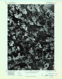
1975 Map of Stetson NE
USGS Topo · Published 1980About this map
Exeter Mills and the surrounding woodlands of Penobscot County are captured in this mid-1970s orthophotoquad, which uses aerial photography to reveal the precise textures of the Maine landscape. The imagery clearly delineates the patchwork of agricultural clearings and dense forest that defines the region between East Corinth and West Levant. This aerial perspective provides an unfiltered look at the rural road network and settlement patterns of the era, from the concentrated cluster at East Exeter to the winding course of Kenduskeag Stream. In the southern portion of the sheet, the dark expanse of Pleasant Lake stands out against the wooded terrain, offering a clear view of the shoreline and drainage patterns before modern development altered these rural corridors.
Find a feature on this map
6 named features on this map. Tap any name to fly to it.
Don’t see what you’re looking for? This feature index may not catch every label — zoom into the map to look around manually.
Map Details
Editions of this 1975 Stetson NE Map
This is the sole edition of this map. No revisions or reprints were ever made.
Other maps of this area

1902 · Bangor
USGS Topo · 1:62,500

1931 · Stetson
USGS Topo · 1:48,000

1932 · Dover-Foxcroft
USGS Topo · 1:48,000

1933 · Boyd Lake
USGS Topo · 1:62,500

1935 · Dover-Foxcroft
USGS Topo · 1:62,500

1935 · Stetson
USGS Topo · 1:62,500

1942 · Bangor
USGS Topo · 1:62,500

1946 · Bangor
USGS Topo · 1:62,500

1948 · Bangor
USGS Topo · 1:250,000

1951 · Boyd Lake
USGS Topo · 1:50,000