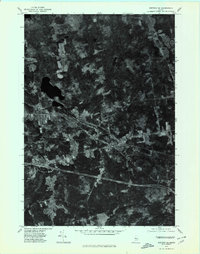
1976 Map of Stetson SE
USGS Topo · Published 1980About this map
Carmel and its surrounding hamlets are captured in this mid-1970s orthophotoquad, which uses aerial photography from 1975 to provide a detailed view of the Maine landscape. The image clearly shows the intersection of local roads and the interstate corridor as it cuts through the wooded terrain of Penobscot County. Small residential clusters at South Levant, Damascus, and Etna Center are visible alongside the meandering path of Souadabscook Stream. Unlike a traditional topographic map, this photographic record reveals the exact footprint of forest clearings, agricultural fields, and the precise layout of the village of Etna. It provides a tangible sense of the rural development and land use patterns as they existed before the growth of recent decades.
Find a feature on this map
6 named features on this map. Tap any name to fly to it.
Don’t see what you’re looking for? This feature index may not catch every label — zoom into the map to look around manually.
Map Details
Editions of this 1976 Stetson SE Map
This is the sole edition of this map. No revisions or reprints were ever made.
Other maps of this area

1900 · Bucksport
USGS Topo · 1:62,500

1902 · Bucksport
USGS Topo · 1:62,500

1902 · Bangor
USGS Topo · 1:62,500

1931 · Stetson
USGS Topo · 1:48,000

1932 · Brooks
USGS Topo · 1:62,500

1935 · Stetson
USGS Topo · 1:62,500

1942 · Bangor
USGS Topo · 1:62,500

1942 · Bucksport
USGS Topo · 1:62,500

1946 · Bangor
USGS Topo · 1:62,500

1948 · Bangor
USGS Topo · 1:250,000