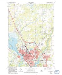
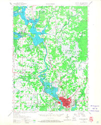
1956 Map of Stevens Point
USGS Topo · Published 1958About this map
Stevens Point serves as the focal point of this mid-1950s survey, situated where the Wisconsin River meets the Plover River. The city is depicted as a growing educational and regional hub, featuring the State Teachers College, St Josephs Academy, and Pacelli High Sch. North of the city, the landscape is defined by the expanse of Lake Du Bay and the Big Eau Pleine reservoir, while a large Cranberry Bog sits west of the river in the township of Eau Pleine. A significant number of rural schoolhouses are marked as abandoned by this date, including the Wilson Sch, Lake View Sch, and St Casimirs Sch, reflecting the mid-century consolidation of rural Wisconsin school districts. The rail infrastructure of the Minneapolis St Paul and Sault Ste Marie and Chicago and North Western lines continues to shape the transport corridor through the river valley.
Find a feature on this map
72 named features on this map. Tap any name to fly to it.
Don’t see what you’re looking for? This feature index may not catch every label — zoom into the map to look around manually.
Map Details
Editions of this 1956 Stevens Point Map
2 editions found
Historical Maps of Stevens Point Through Time
7 maps found