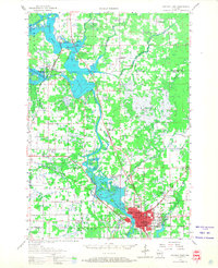
1956 Map of Stevens Point
USGS Topo · Published 1968About this map
The Wisconsin River corridor south of the Marathon and Portage County line reveals a landscape of industrial expansion and rural educational centers in the mid-1950s. The city of Stevens Point serves as the regional anchor, home to the State Teachers College, St Josephs Academy, and Pacelli High Sch. The map illustrates a period of transition for the rural hinterland, noting several defunct local institutions such as Wilson Sch and Sims Sch.
Find a feature on this map
72 named features on this map. Tap any name to fly to it.
Don’t see what you’re looking for? This feature index may not catch every label — zoom into the map to look around manually.
Map Details
Editions of this 1956 Stevens Point Map
2 editions found
Other maps of this area

1899 · Wausau
USGS Topo · 1:125,000

1902 · Wausau
USGS Topo · 1:125,000

1902 · Marathon
USGS Topo · 1:125,000

1953 · Wausau
USGS Topo · 1:48,000

1953 · Marathon
USGS Topo · 1:48,000

1953 · Hatley
USGS Topo · 1:48,000

1955 · Rosholt
USGS Topo · 1:48,000

1955 · Green Bay
USGS Topo · 1:250,000

1956 · Milladore
USGS Topo · 1:48,000

1956 · Stevens Point
USGS Topo · 1:48,000