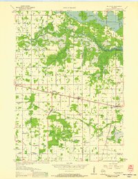
1956 Map of Milladore
USGS Topo · Published 1958About this map
The central Wisconsin dairy and timber lands of Wood, Marathon, and Portage Counties are defined here by a dense grid of rural schoolhouses and rail-dependent settlements. The Minneapolis St Paul and Sault Ste Marie corridor links the village of Auburndale to Milladore and Blenker, while Junction City marks the intersection with the Chicago Milwaukee St Paul and Pacific line to the east.
Find a feature on this map
54 named features on this map. Tap any name to fly to it.
Don’t see what you’re looking for? This feature index may not catch every label — zoom into the map to look around manually.
Map Details
Editions of this 1956 Milladore Map
This is the sole edition of this map. No revisions or reprints were ever made.
Other maps of this area

1899 · Wausau
USGS Topo · 1:125,000

1902 · Wausau
USGS Topo · 1:125,000

1902 · Marathon
USGS Topo · 1:125,000

1953 · Wausau
USGS Topo · 1:48,000

1953 · Marathon
USGS Topo · 1:48,000
1953 · Stratford
USGS Topo · 1:48,000

1953 · Eau Claire
USGS Topo · 1:250,000
1954 · Marshfield
USGS Topo · 1:62,500

1955 · Green Bay
USGS Topo · 1:250,000

1956 · Stevens Point
USGS Topo · 1:48,000