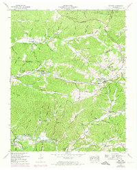
1950 Map of Stewart
USGS Topo · Published 1974About this map
Stewart and Tennessee Ridge anchor this mid-century look at the borderlands of Stewart and Houston Counties, where the Louisville and Nashville railroad winds through the complex topography of the Tennessee Ridge. The landscape is defined by its numerous small burial grounds and rural congregations, including Hurricane Creek Church, Crossroads Ch, and Pleasant Valley Church. These features, along with family-named sites like Collier Cem and McIntosh Cem, reflect a deeply rooted settlement pattern established well before the mid-20th-century revisions.
Find a feature on this map
51 named features on this map. Tap any name to fly to it.
Don’t see what you’re looking for? This feature index may not catch every label — zoom into the map to look around manually.
Map Details
Editions of this 1950 Stewart Map
3 editions found

Other maps of this area

1931 · Erin
USGS Topo · 1:62,500

1936 · Tantrough Hollow
USGS Topo · 1:24,000

1936 · McKinnon
USGS Topo · 1:24,000

1936 · Woolworth
USGS Topo · 1:24,000

1936 · Stewart
USGS Topo · 1:24,000

1936 · Halls Creek
USGS Topo · 1:24,000

1936 · Harmon Creek
USGS Topo · 1:24,000

1936 · Standing Rock
USGS Topo · 1:24,000

1936 · Dover
USGS Topo · 1:24,000

1949 · Harmon Creek
USGS Topo · 1:24,000