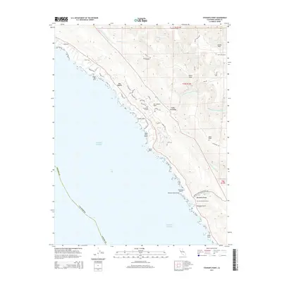
2015 Map of Stewarts Point
USGS Topo · Published 2015About this map
Sea Ranch and the coastal hamlet of Stewarts Point anchor this Sonoma County coastline, where the land drops sharply from ridges into the Pacific Ocean. The geography is defined by the underlying San Andreas Fault, which runs parallel to the shore, influencing the course of the South Fork Gualala River. This area shows a mix of planned coastal development and older rural foundations, with The Sea Ranch Airport serving the northern reaches and historic local sites like the Buckeye Creek Cemetery and Stewarts Point Cemetery providing links to early families.
Find a feature on this map
56 named features on this map. Tap any name to fly to it.
Don’t see what you’re looking for? This feature index may not catch every label — zoom into the map to look around manually.
Map Details
Editions of this 2015 Stewarts Point Map
This is the sole edition of this map. No revisions or reprints were ever made.
Other maps of this area

1921 · Plantation
USGS Topo · 1:62,500

1943 · Point Arena
USGS Topo · 1:62,500

1943 · Stewarts Point
USGS Topo · 1:24,000

1943 · Plantation
USGS Topo · 1:24,000

1943 · Annapolis
USGS Topo · 1:24,000

1943 · Ornbaun
USGS Topo · 1:62,500

1944 · Annapolis
USGS Topo · 1:31,680
1944 · Plantation
USGS Topo · 1:31,680

1944 · Stewarts Point
USGS Topo · 1:31,680

1944 · Ornbaun
USGS Topo · 1:62,500