
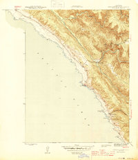
1944 Map of Stewarts Point
USGS Topo · Published 1944About this map
Stewarts Point and the adjacent Fisherman Bay anchor this 1944 survey of the Sonoma County coastline. The landscape is defined by the sharp descent from Miller Ridge and Stanley Ridge toward the Pacific Ocean, carved by the South Fork Gualala River and the Wheatfield Fork Gualala River. Historical maritime activity is evident at Del Mar Landing and Black Pt Landing, reflecting an era when these coastal points served as vital links for local commerce. Inland, the map captures the transition from steep ridges to the interior drainage of Buckeye Creek and Brush Creek. Small settlements like Valley Crossing mark the junction of river valleys and early road networks, providing a detailed look at the rural infrastructure of Northern California during the mid-1940s.
Find a feature on this map
20 named features on this map. Tap any name to fly to it.
Don’t see what you’re looking for? This feature index may not catch every label — zoom into the map to look around manually.
Map Details
Editions of this 1944 Stewarts Point Map
2 editions found
Other maps of this area

1921 · Plantation
USGS Topo · 1:62,500

1943 · Point Arena
USGS Topo · 1:62,500

1943 · Stewarts Point
USGS Topo · 1:24,000

1943 · Plantation
USGS Topo · 1:24,000

1943 · Annapolis
USGS Topo · 1:24,000

1943 · Ornbaun
USGS Topo · 1:62,500

1944 · Annapolis
USGS Topo · 1:31,680
1944 · Plantation
USGS Topo · 1:31,680

1944 · Ornbaun
USGS Topo · 1:62,500

1947 · Santa Rosa
USGS Topo · 1:250,000