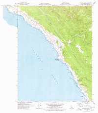
1978 Map of Stewarts Point
USGS Topo · Published 1978About this map
The San Andreas Fault Zone dominates the structural character of this coastal landscape, running parallel to the rugged shoreline and influencing the path of the South Fork Gualala River. Along the coast, small maritime and residential pockets such as Del Mar Landing and Stewarts Point serve as focal points for this stretch of Sonoma County. The map captures the region in the late 1970s, showcasing the development of the Sea Ranch Airport and the coastal clusters around Black Point contrasted with the more isolated interior ridges.
Find a feature on this map
27 named features on this map. Tap any name to fly to it.
Don’t see what you’re looking for? This feature index may not catch every label — zoom into the map to look around manually.
Map Details
Editions of this 1978 Stewarts Point Map
This is the sole edition of this map. No revisions or reprints were ever made.
Other maps of this area

1921 · Plantation
USGS Topo · 1:62,500

1943 · Point Arena
USGS Topo · 1:62,500

1943 · Stewarts Point
USGS Topo · 1:24,000

1943 · Plantation
USGS Topo · 1:24,000

1943 · Annapolis
USGS Topo · 1:24,000

1943 · Ornbaun
USGS Topo · 1:62,500

1944 · Annapolis
USGS Topo · 1:31,680
1944 · Plantation
USGS Topo · 1:31,680

1944 · Stewarts Point
USGS Topo · 1:31,680

1944 · Ornbaun
USGS Topo · 1:62,500