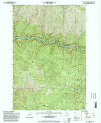
1995 Map of Stillman Point
USGS Topo · Published 1999About this map
The Middle Fork Selway River carves through this remote interior of the Nez Perce National Forest, defining a landscape where waterway and trail were the primary arteries of movement in the mid-1990s. This survey illustrates the wild character of the Selway-Bitterroot Wilderness north of the river, contrasted by the thin thread of the Selway Elk City Road tracing the southern banks. High-elevation vantage points like Stillman Point, Sob Point, and O'Hara Point look down upon deep drainage systems including Falls Creek and Boyd Creek. The presence of the Ranger District along the southern road corridor highlights the administrative management of these public lands during an era of significant forest service activity. Distinctive terrain features such as Rock Island and Saddle Ridge provide critical landmarks for those navigating this steep, wooded Idaho backcountry.
Find a feature on this map
16 named features on this map. Tap any name to fly to it.
Don’t see what you’re looking for? This feature index may not catch every label — zoom into the map to look around manually.
Map Details
Editions of this 1995 Stillman Point Map
This is the sole edition of this map. No revisions or reprints were ever made.
Other maps of this area

1911 · Lolo
USGS Topo · 1:250,000

1913 · Lolo
USGS Topo · 1:250,000

1924 · Weippe
USGS Topo · 1:125,000

1931 · Buffalo Hump
USGS Topo · 1:125,000

1934 · Buffalo Hump
USGS Topo · 1:125,000

1956 · Elk City
USGS Topo · 1:250,000

1956 · Hamilton
USGS Topo · 1:250,000

1959 · Hamilton
USGS Topo · 1:250,000

1960 · Elk City
USGS Topo · 1:250,000

1960 · Hamilton
USGS Topo · 1:250,000