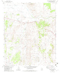
1982 Map of Stinking Springs
USGS Topo · Published 1983About this map
Hunt Valley and the surrounding high country of Apache County are captured here in the early 1980s, showcasing a landscape defined by seasonal water and scattered ranching infrastructure. The Little Colorado River winds across the northern reaches, flanked by prominent elevations like Stinking Springs Mtn and South Mtn. Evidence of early settlement and land use is visible through family-named landmarks such as Greer Place and the Greer Windmill, alongside numerous unnamed ruins and corrals that suggest a history of livestock management in this arid environment.
Find a feature on this map
22 named features on this map. Tap any name to fly to it.
Don’t see what you’re looking for? This feature index may not catch every label — zoom into the map to look around manually.
Map Details
Editions of this 1982 Stinking Springs Map
This is the sole edition of this map. No revisions or reprints were ever made.
Other maps of this area

1886 · St Johns
USGS Topo · 1:250,000

1892 · St Johns
USGS Topo · 1:250,000

1954 · Saint Johns
USGS Topo · 1:250,000

1955 · Adamana 4 SW
USGS Topo · 1:24,000

1955 · Adamana 4 NE
USGS Topo · 1:24,000

1955 · Adamana 4 NW
USGS Topo · 1:24,000

1955 · Wolford Springs 3 NW
USGS Topo · 1:24,000

1955 · Adamana 4 SE
USGS Topo · 1:24,000

1955 · Wolford Springs 3 SW
USGS Topo · 1:24,000

1955 · Hunt
USGS Topo · 1:62,500