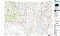
1978 Map of Stinkingwater Mountains
USGS Topo · Published 1997About this map
The Stinkingwater Mountains dominate the central landscape of this eastern Oregon region, dividing the high desert basins and valleys. To the west, the historical Fort Harney (Site) marks a point of early frontier transition near the foothills of the Malheur National Forest. The map documents a complex hydraulic landscape where the Silvies River and Malheur River are managed through significant infrastructure like the Beulah Reservoir and Warm Springs Reservoir.
Find a feature on this map
61 named features on this map. Tap any name to fly to it.
Don’t see what you’re looking for? This feature index may not catch every label — zoom into the map to look around manually.
Map Details
Editions of this 1978 Stinkingwater Mountains Map
2 editions found
Other maps of this area

1908 · Ironside Mountain
USGS Topo · 1:125,000

1955 · Baker
USGS Topo · 1:250,000

1955 · Burns
USGS Topo · 1:250,000

1955 · Canyon City
USGS Topo · 1:250,000

1955 · Boise
USGS Topo · 1:250,000

1958 · Burns
USGS Topo · 1:250,000

1958 · Boise
USGS Topo · 1:250,000

1959 · Baker
USGS Topo · 1:250,000

1959 · Burns
USGS Topo · 1:250,000

1959 · Canyon City
USGS Topo · 1:250,000