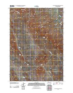
2011 Map of Stockade Mountain
USGS Topo · Published 2011About this map
Stockade Mountain and the surrounding high desert of Malheur County are defined by a complex network of seasonal drainages and prominent volcanic landforms. The terrain is anchored by significant elevations such as Stockade Buttes, Whitehorse Mountain, and the Swamp Creek Buttes in the north. Water security in this arid landscape is marked by isolated features like Coyote Springs, Helpful Spring, and Soldier Spring, which served as critical landmarks for travelers and livestock in the early 21st century. The drainage patterns of Juniper Creek and Stockade Creek illustrate the natural runoff routes toward the Owyhee region. Human presence is concentrated along the Crowley-Riverside Rd, which provides the primary transit corridor through this expanse of basin and range country.
Find a feature on this map
15 named features on this map. Tap any name to fly to it.
Don’t see what you’re looking for? This feature index may not catch every label — zoom into the map to look around manually.
Map Details
Editions of this 2011 Stockade Mountain Map
This is the sole edition of this map. No revisions or reprints were ever made.
Other maps of this area

1955 · Burns
USGS Topo · 1:250,000

1955 · Boise
USGS Topo · 1:250,000

1958 · Burns
USGS Topo · 1:250,000

1958 · Boise
USGS Topo · 1:250,000

1959 · Burns
USGS Topo · 1:250,000

1962 · Boise
USGS Topo · 1:250,000

1972 · Crowley
USGS Topo · 1:24,000
1972 · Mustang Butte
USGS Topo · 1:24,000
1972 · Star Creek Reservoir
USGS Topo · 1:24,000
1972 · Mc Ewen Butte
USGS Topo · 1:24,000