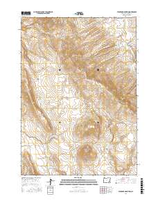
2017 Map of Stockade Mountain
USGS Topo · Published 2017About this map
Stockade Mountain and the neighboring Stockade Buttes anchor this high-desert landscape in southeastern Oregon. This 2017 survey reveals a complex hydrological network of ephemeral drainages and named water sources essential to the region's ranching and wilderness character. Vital water points such as Coyote Springs, Helpful Spring, and Soldier Spring are mapped alongside the deep incisions of Box Canyon. Human passage through this high terrain is concentrated along the Crowley-Riverside Rd, which skirts the eastern edge of the quadrangle near Crowley Cr. The map details the drainage patterns of Stockade Cr and Meadow Cr, illustrating how water moves through the volcanic topography of Whitehorse Mtn and the northern Swamp Creek Buttes.
Find a feature on this map
22 named features on this map. Tap any name to fly to it.
Don’t see what you’re looking for? This feature index may not catch every label — zoom into the map to look around manually.
Map Details
Editions of this 2017 Stockade Mountain Map
This is the sole edition of this map. No revisions or reprints were ever made.
Other maps of this area

1955 · Burns
USGS Topo · 1:250,000

1955 · Boise
USGS Topo · 1:250,000

1958 · Burns
USGS Topo · 1:250,000

1958 · Boise
USGS Topo · 1:250,000

1959 · Burns
USGS Topo · 1:250,000

1962 · Boise
USGS Topo · 1:250,000

1972 · Crowley
USGS Topo · 1:24,000
1972 · Mustang Butte
USGS Topo · 1:24,000
1972 · Star Creek Reservoir
USGS Topo · 1:24,000
1972 · Mc Ewen Butte
USGS Topo · 1:24,000