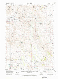
1972 Map of Stockade Mtn
USGS Topo · Published 1976About this map
The South Fork Malheur River carves through this high-desert landscape on the border of Harney and Malheur counties, a region where water sources dictate the placement of every homestead and landmark. Ranching history is deeply etched into the terrain, evidenced by family holdings such as the McEwen Ranch and Spurlock Ranch, along with the Grave McRae Homestead near the river. The presence of the Union Pacific rail line and Luce Hot Springs highlights the strategic importance of this corridor in the early 1970s. Cattle operations appear central to the local geography, with specifically named infrastructure like Dipping Vat Spring and numerous stock waterings including Hat Butte Waterhole and the Jake Hughes Reservoir. The map illustrates a network of fences and primitive trails connecting remote heights like Stockade Mountain to the seasonal drainages of Swamp Creek and Visher Creek.
Find a feature on this map
54 named features on this map. Tap any name to fly to it.
Don’t see what you’re looking for? This feature index may not catch every label — zoom into the map to look around manually.
Map Details
Editions of this 1972 Stockade Mtn Map
This is the sole edition of this map. No revisions or reprints were ever made.
Other maps of this area

1955 · Burns
USGS Topo · 1:250,000

1955 · Boise
USGS Topo · 1:250,000

1958 · Burns
USGS Topo · 1:250,000

1958 · Boise
USGS Topo · 1:250,000

1959 · Burns
USGS Topo · 1:250,000

1962 · Boise
USGS Topo · 1:250,000

1968 · Venator
USGS Topo · 1:62,500

1972 · Shumway Reservoir
USGS Topo · 1:24,000

1972 · Crowley
USGS Topo · 1:24,000
1972 · Mustang Butte
USGS Topo · 1:24,000