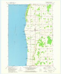
1974 Map of Stockbridge
USGS Topo · Published 1978About this map
Lake Winnebago defines the western edge of this 1974 survey, where the shoreline is punctuated by a series of harbors and small beaches including Stockbridge Harbor and Mud Creek Harbor. The landscape is marked by the Old Indian Treaty Boundary, a historical dividing line that separates the township of Stockbridge from Brothertown. Inland, the terrain rises toward the Ledge, with agricultural lands interspersed with small communities like Kloten and Quinney. Genealogy researchers will find significant value in the numerous burial sites across the quadrangle, from the Indian Cem near Mill Creek to family-named plots such as Dorn Cem and Pingel Cem. Cultural centers are anchored by St Marys Ch and St Elizabeth Ch, reflecting the established rural parishes of Calumet County during this era.
Find a feature on this map
57 named features on this map. Tap any name to fly to it.
Don’t see what you’re looking for? This feature index may not catch every label — zoom into the map to look around manually.
Map Details
Editions of this 1974 Stockbridge Map
This is the sole edition of this map. No revisions or reprints were ever made.
Other maps of this area

1910 · Fond du Lac
USGS Topo · 1:62,500

1911 · Neenah
USGS Topo · 1:62,500

1954 · Chilton
USGS Topo · 1:62,500

1954 · Kiel
USGS Topo · 1:62,500

1955 · Neenah
USGS Topo · 1:62,500

1955 · Neenah
USGS Topo · 1:24,000

1955 · Fond Du Lac
USGS Topo · 1:62,500

1955 · Green Bay
USGS Topo · 1:250,000

1957 · Madison
USGS Topo · 1:250,000

1960 · Madison
USGS Topo · 1:250,000