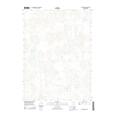
2014 Map of Stockdale Lake
USGS Topo · Published 2014About this map
Stockdale Lake sits at the heart of this Rock County landscape, which is defined by a dense network of semi-permanent water bodies and marshes characteristic of the Nebraska Sandhills. The topography reveals a complex system of depressions and rises where Peterson Lake and the Twin Lakes collect surface runoff. In the northern reaches, Holt Cr meanders through the terrain, eventually flowing past Scotty Lake and toward Fish Lake in the northeast corner. Unlike many agricultural regions, the sparse road network, represented here by 859th Rd, suggests a landscape primarily dedicated to ranching and conservation. The abundance of these named lakes indicates the importance of reliable water sources in this high-plains environment, where localized basins serve as critical landmarks and resources for local land management.
Find a feature on this map
7 named features on this map. Tap any name to fly to it.
Don’t see what you’re looking for? This feature index may not catch every label — zoom into the map to look around manually.
Map Details
Editions of this 2014 Stockdale Lake Map
This is the sole edition of this map. No revisions or reprints were ever made.
Other maps of this area

1955 · O'Neill
USGS Topo · 1:250,000

1959 · O'Neill
USGS Topo · 1:250,000

1969 · O'Neill
USGS Topo · 1:250,000

1981 · Stonehouse Ranch NW
USGS Topo · 1:24,000

1981 · Stonehouse Ranch NE
USGS Topo · 1:24,000

1981 · Rose
USGS Topo · 1:24,000
1982 · Linke Lake
USGS Topo · 1:24,000

1982 · Hagan Lake NE
USGS Topo · 1:24,000

1982 · Stockdale Lake
USGS Topo · 1:24,000

1982 · Sybrant
USGS Topo · 1:24,000