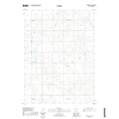
2017 Map of Stockdale Lake
USGS Topo · Published 2017About this map
Stockdale Lake and the surrounding Nebraska Sandhills landscape of Rock County are defined by a collection of isolated water bodies and winding seasonal drainages. This high plains environment is marked by Peterson Lake, Fish Lake, and the small Twin Lakes basin, which provide critical water sources in a region characterized by sparse settlement. The map reveals a highly structured grid of section lines and rural tracks, such as Division Rd and Eagles Nest Ave, which segment the terrain into large-scale ranching and grazing tracts. The erratic course of Holt Creek cuts through the northern sections, showing how natural hydrology ignores the rigid township and range boundaries of t28n r19w and t27n r18w. This survey provides a precise look at the modern land use patterns and critical water features of a remote Nebraska rangeland.
Find a feature on this map
19 named features on this map. Tap any name to fly to it.
Don’t see what you’re looking for? This feature index may not catch every label — zoom into the map to look around manually.
Map Details
Editions of this 2017 Stockdale Lake Map
This is the sole edition of this map. No revisions or reprints were ever made.
Other maps of this area

1955 · O'Neill
USGS Topo · 1:250,000

1959 · O'Neill
USGS Topo · 1:250,000

1969 · O'Neill
USGS Topo · 1:250,000

1981 · Stonehouse Ranch NW
USGS Topo · 1:24,000

1981 · Stonehouse Ranch NE
USGS Topo · 1:24,000

1981 · Rose
USGS Topo · 1:24,000
1982 · Linke Lake
USGS Topo · 1:24,000

1982 · Hagan Lake NE
USGS Topo · 1:24,000

1982 · Stockdale Lake
USGS Topo · 1:24,000

1982 · Sybrant
USGS Topo · 1:24,000