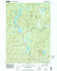
1998 Map of Stoddard
USGS Topo · Published 2002About this map
Highland Lake serves as a central feature of this terrain, stretching across the border of Stoddard where several small settlements are clustered. Mill Village and South Stoddard represent the localized centers of activity, while the name Loverens Mill on the North Branch River points to the historical importance of water-powered industry in the region. The landscape is characterized by a high concentration of named peaks and ridges, including Windsor Mtn, Nancy Mtn, and Tuttle Hill, which enclose numerous smaller basins like Island Pond and Willard Pond.
Find a feature on this map
63 named features on this map. Tap any name to fly to it.
Don’t see what you’re looking for? This feature index may not catch every label — zoom into the map to look around manually.
Map Details
Editions of this 1998 Stoddard Map
This is the sole edition of this map. No revisions or reprints were ever made.
Other maps of this area

1898 · Monadnock
USGS Topo · 1:62,500

1900 · Peterboro
USGS Topo · 1:62,500

1926 · Hillsboro
USGS Topo · 1:62,500

1929 · Hillsboro
USGS Topo · 1:62,500

1930 · Lovewell Mountain
USGS Topo · 1:62,500

1936 · Monadnock
USGS Topo · 1:62,500

1942 · Keene
USGS Topo · 1:125,000

1942 · Lovewell Mountain
USGS Topo · 1:62,500

1943 · Fitchburg
USGS Topo · 1:125,000

1948 · Boston
USGS Topo · 1:250,000