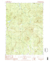
1988 Map of Stone Mountain
USGS Topo · Published 1988About this map
Stone Mountain stands as the central topographic feature in this late-twentieth-century study of the borderlands between Granby, Guildhall, and Maidstone. The landscape is defined by a dense network of mountain peaks and water systems, where the northern reaches touch Maidstone State Park and the headwaters of Stony Brook. A small Cem and a Gravel Pit near Granby Brook provide the only evidence of concentrated human utility in this largely undeveloped terrain. The drainage patterns are intricate, with Cutler Brook, Mill Brook, and Washburn Brook carving through the granite heights of Sable Mtn and Burnside Mtn. This map captures a moment of transition for the region, documenting the network of unimproved roads and trails that connected these high-elevation settlements before further modernization.
Find a feature on this map
47 named features on this map. Tap any name to fly to it.
Don’t see what you’re looking for? This feature index may not catch every label — zoom into the map to look around manually.
Map Details
Editions of this 1988 Stone Mountain Map
This is the sole edition of this map. No revisions or reprints were ever made.
Other maps of this area

1900 · Whitefield
USGS Topo · 1:62,500

1920 · Guildhall
USGS Topo · 1:62,500

1931 · Guildhall
USGS Topo · 1:48,000

1931 · Littleton
USGS Topo · 1:62,500

1932 · Littleton
USGS Topo · 1:48,000

1933 · Guildhall
USGS Topo · 1:48,000

1935 · Littleton
USGS Topo · 1:62,500

1935 · Whitefield
USGS Topo · 1:48,000

1937 · Guildhall
USGS Topo · 1:62,500

1938 · Whitefield
USGS Topo · 1:62,500