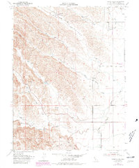
1952 Map of Stone Valley
USGS Topo · Published 1981About this map
Stone Valley serves as a stark example of the working ranch lands and drainage systems of Glenn County during the mid-20th century. The landscape is defined by its complex hydrology, with numerous seasonal and permanent waterways like White Cabin Creek, Salt Gulch, and Hayes Hollow Creek carving through the terrain. A sparse human imprint is centered on the French Ranch and a solitary Cem located near the South Fork Willow Creek, suggesting a long-standing but low-density agricultural presence.
Find a feature on this map
21 named features on this map. Tap any name to fly to it.
Don’t see what you’re looking for? This feature index may not catch every label — zoom into the map to look around manually.
Map Details
Editions of this 1952 Stone Valley Map
4 editions found
Other maps of this area

1904 · Walker Creek
USGS Topo · 1:31,680

1904 · Logan Creek
USGS Topo · 1:24,000

1906 · Maxwell
USGS Topo · 1:62,500

1906 · Willows
USGS Topo · 1:62,500

1914 · Orland
USGS Topo · 1:31,680

1917 · Kurand
USGS Topo · 1:31,680

1917 · Lyman
USGS Topo · 1:31,680

1917 · Logandale
USGS Topo · 1:31,680

1918 · Logan Creek
USGS Topo · 1:31,680

1919 · Fruto
USGS Topo · 1:62,500