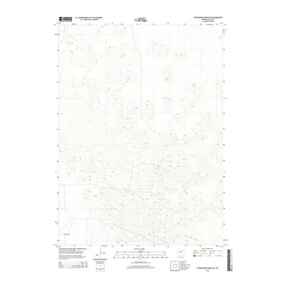
2014 Map of Stonehouse Ranch NE
USGS Topo · Published 2014About this map
Gracie Flats and the surrounding terrain of Rock County define this portion of the Nebraska Sandhills as it was recorded in 2014. The map reveals a landscape dominated by complex dune structures and interdunal valleys, characteristic of this unique physiographic region. In the northeast corner, Long Lake serves as a primary water feature among the depressions of the sandy plains. The absence of developed townsites or dense road networks reflects the specialized grazing and ranching economy that has historically shaped this part of the state, where vast tracts of land remain sparsely settled and centered on the management of natural water resources and prairie grass.
Find a feature on this map
2 named features on this map. Tap any name to fly to it.
Don’t see what you’re looking for? This feature index may not catch every label — zoom into the map to look around manually.
Map Details
Editions of this 2014 Stonehouse Ranch NE Map
This is the sole edition of this map. No revisions or reprints were ever made.
Other maps of this area

1955 · O'Neill
USGS Topo · 1:250,000

1959 · O'Neill
USGS Topo · 1:250,000

1969 · O'Neill
USGS Topo · 1:250,000

1981 · Bruner Lake
USGS Topo · 1:24,000

1981 · Stonehouse Ranch NW
USGS Topo · 1:24,000

1981 · Stonehouse Ranch NE
USGS Topo · 1:24,000
1981 · Carson Lake
USGS Topo · 1:24,000
1981 · Stonehouse Ranch
USGS Topo · 1:24,000
1981 · Stonehouse Ranch SW
USGS Topo · 1:24,000

1982 · Stockdale Lake
USGS Topo · 1:24,000