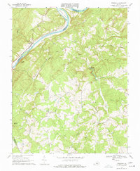
1968 Map of Stonewall
USGS Topo · Published 1977About this map
The James River forms the primary geographic spine of this central Virginia landscape, acting as a natural boundary between Amherst and Appomattox Counties. Along its southern bank, the Chesapeake and Ohio River tracks the water's path, serving the small community of Stapleton. The interior is defined by a dense network of waterways like Wreck Island Creek and Stonewall Creek, which likely powered the local industry suggested by Stonewall Mills. Genealogists and local historians can find a wealth of community landmarks, including numerous rural houses of worship such as Mt Zion Ch, Bethel Ch, and Trinity Ch. The map also details the extractive history of the region with several marked Quarry and Quarries sites scattered across the hills near Beckham.
Find a feature on this map
32 named features on this map. Tap any name to fly to it.
Don’t see what you’re looking for? This feature index may not catch every label — zoom into the map to look around manually.
Map Details
Editions of this 1968 Stonewall Map
2 editions found
Other maps of this area

1892 · Lynchburg
USGS Topo · 1:125,000

1892 · Buckingham
USGS Topo · 1:125,000

1892 · Appomattox
USGS Topo · 1:125,000

1894 · Lexington
USGS Topo · 1:125,000

1935 · Amherst
USGS Topo · 1:48,000

1939 · Amherst
USGS Topo · 1:62,500

1944 · Lynchburg
USGS Topo · 1:62,500

1947 · Roanoke
USGS Topo · 1:250,000

1950 · Amherst
USGS Topo · 1:62,500

1950 · Lynchburg
USGS Topo · 1:62,500