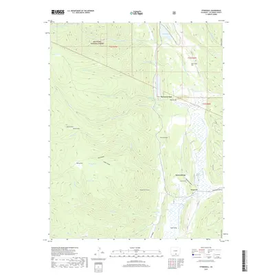
2019 Map of Stonewall
USGS Topo · Published 2019About this map
Stonewall lies at the heart of this landscape where the Middle Fork Purgatoire River meets the distinctive geological barrier of Stonewall Gap. This survey documents the valley's complex water management system, including the extensive Maxwell Ditch Number 19 and 20 and Russell Reservoir, which support the local agriculture. To the north and west, the terrain rises into the San Isabel National Forest, characterized by high-elevation landmarks like Hayrack Mtn and the tranquil Duling Lakes. Settlement patterns follow the river and the path of Hwy 12, with the community anchored by The Stonewall and the local Stonewall Cem. The map provides a detailed view of the interaction between the valley floor and the high country parks such as Wilkins Park and Monument Park.
Find a feature on this map
51 named features on this map. Tap any name to fly to it.
Don’t see what you’re looking for? This feature index may not catch every label — zoom into the map to look around manually.
Map Details
Editions of this 2019 Stonewall Map
This is the sole edition of this map. No revisions or reprints were ever made.
Other maps of this area

1891 · Spanish Peaks
USGS Topo · 1:125,000

1893 · Spanish Peaks
USGS Topo · 1:125,000

1895 · Spanish Peaks
USGS Topo · 1:125,000

1897 · Spanish Peaks
USGS Topo · 1:125,000

1900 · Spanish Peaks
USGS Topo · 1:125,000

1954 · Trinidad
USGS Topo · 1:250,000

1955 · Trinidad
USGS Topo · 1:250,000

1958 · Trinidad
USGS Topo · 1:250,000

1959 · Trinidad
USGS Topo · 1:250,000
1967 · Cucharas Pass
USGS Topo · 1:24,000