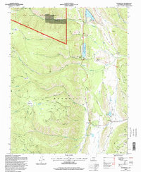
1994 Map of Stonewall
USGS Topo · Published 1998About this map
Stonewall lies along the banks of the North Fork Purgatoire River, situated within the rugged Stonewall Valley. This 1990s revision reveals a landscape defined by significant water management and land tenure history, notably marked by the Maxwell Grant Boundary cutting through the San Isabel National Forest. Local history is anchored by the Stonewall Cem and the Stonewall Gap, a distinctive geological break where the river flows east. The presence of the Monument Lake Spillway and a Filtration Plant near Coal Creek Flat indicates the area's role in regional water infrastructure. High-altitude lakes like North Lake, South Lake, and Rainbow Lake dot the terrain, while old prospecting sites and gravel pits suggest a history of resource extraction alongside the Legends Scenic Byway corridor.
Find a feature on this map
40 named features on this map. Tap any name to fly to it.
Don’t see what you’re looking for? This feature index may not catch every label — zoom into the map to look around manually.
Map Details
Editions of this 1994 Stonewall Map
This is the sole edition of this map. No revisions or reprints were ever made.
Other maps of this area

1891 · Spanish Peaks
USGS Topo · 1:125,000

1893 · Spanish Peaks
USGS Topo · 1:125,000

1895 · Spanish Peaks
USGS Topo · 1:125,000

1897 · Spanish Peaks
USGS Topo · 1:125,000

1900 · Spanish Peaks
USGS Topo · 1:125,000

1954 · Trinidad
USGS Topo · 1:250,000

1955 · Trinidad
USGS Topo · 1:250,000

1958 · Trinidad
USGS Topo · 1:250,000

1959 · Trinidad
USGS Topo · 1:250,000
1967 · Cucharas Pass
USGS Topo · 1:24,000