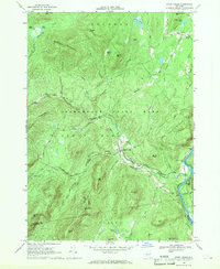
1968 Map of Stony Creek
USGS Topo · Published 1969About this map
Adirondack State Park encompasses much of this 1960s landscape, where the town of Stony Creek serves as a central hub for the surrounding mountains and waterways. The eastern border is defined by the Hudson River, followed closely by the tracks of the Delaware and Hudson Railroad and the Stony Creek Sta. This area reveals a transition from the river valley industry to the high peaks of the southern Adirondacks, including Baldhead Mountain and Hadley Mtn. Local family history is preserved at sites like Harris Cem and the settlement of High Street in the northeast. Higher elevations are marked by a Lookout Tower on Wells Peak, overlooking a dense network of mountain brooks like Roaring Branch and Kibby Brook that feed into the larger creek system.
Find a feature on this map
66 named features on this map. Tap any name to fly to it.
Don’t see what you’re looking for? This feature index may not catch every label — zoom into the map to look around manually.
Map Details
Editions of this 1968 Stony Creek Map
This is the sole edition of this map. No revisions or reprints were ever made.
Other maps of this area

1895 · North Creek
USGS Topo · 1:62,500

1897 · North Creek
USGS Topo · 1:62,500

1898 · Thirteenth Lake
USGS Topo · 1:62,500

1903 · Luzerne
USGS Topo · 1:62,500

1910 · Stony Creek
USGS Topo · 1:62,500

1950 · Glens Falls
USGS Topo · 1:250,000

1950 · Utica
USGS Topo · 1:250,000

1954 · Thirteenth Lake
USGS Topo · 1:62,500

1954 · Harrisburg
USGS Topo · 1:62,500
1955 · Lake Luzerne
USGS Topo · 1:62,500