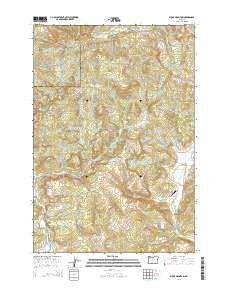
2014 Map of Stony Mountain
USGS Topo · Published 2014About this map
Stony Mountain and Green Top anchor this forested portion of the Northern Oregon Coast Range, where the drainage networks of Willamina Creek and Beaver Cr define the landscape. The map reveals a transition from the steep, timbered ridges of the northwest toward the settled agricultural flats and valleys in the southeast. Historical footprints of early homesteading and rural community life are evident in the scattered burial grounds, including Highland Cem, Hussey Cem, and Buck Hollow Cem.
Find a feature on this map
38 named features on this map. Tap any name to fly to it.
Don’t see what you’re looking for? This feature index may not catch every label — zoom into the map to look around manually.
Map Details
Editions of this 2014 Stony Mountain Map
This is the sole edition of this map. No revisions or reprints were ever made.
Other maps of this area

1942 · Ginger Peak
USGS Topo · 1:62,500

1942 · Sheridan
USGS Topo · 1:62,500

1942 · Spirit Mtn
USGS Topo · 1:62,500

1942 · Fairdale
USGS Topo · 1:62,500

1948 · Vancouver
USGS Topo · 1:250,000

1950 · Vancouver
USGS Topo · 1:250,000

1950 · Vancouver
USGS Topo · 1:250,000

1955 · Blaine
USGS Topo · 1:62,500

1955 · Fairdale
USGS Topo · 1:62,500

1955 · Grand Ronde
USGS Topo · 1:62,500