
1955 Map of Grand Ronde
USGS Topo · Published 1957About this map
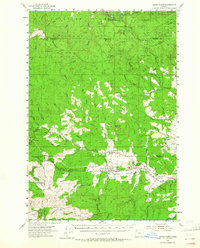
The Grand Ronde Agency and the nearby community of Grand Ronde serve as the focal points for this mid-century survey of the Oregon Coast Range. Located at the intersection of the Coast Highway and the Portland and Northern rail line, the area shows a landscape defined by timber, tribal administration, and small rural outposts. The map documents the intricate social geography of the region, from the Church in the Wildwood and St Michael Sch to more isolated landmarks like Bible Ranch and the Coneridge Sch. The terrain is dominated by significant peaks such as Mount Hebo and Spirit Mtn, while the complex drainage of the Nestucca River and Salmon River systems illustrates the watershed's importance. From the millponds at Fort Hill to the various quarries and forest camps, the map records an era of active land management and community development.
Find a feature on this map
72 named features on this map. Tap any name to fly to it.
Don’t see what you’re looking for? This feature index may not catch every label — zoom into the map to look around manually.
Map Details
Editions of this 1955 Grand Ronde Map
2 editions found
Other maps of this area

1941 · Nestucca Bay
USGS Topo · 1:62,500

1942 · Ginger Peak
USGS Topo · 1:62,500

1942 · Euchre Mtn
USGS Topo · 1:62,500

1942 · Sheridan
USGS Topo · 1:62,500

1942 · Spirit Mtn
USGS Topo · 1:62,500

1942 · Nestucca Bay
USGS Topo · 1:62,500

1942 · Fairdale
USGS Topo · 1:62,500

1942 · Valsetz
USGS Topo · 1:62,500

1942 · Dallas
USGS Topo · 1:62,500

1942 · Tillamook
USGS Topo · 1:62,500