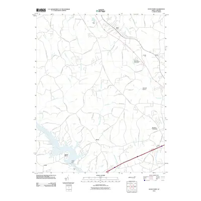
2010 Map of Stony Point
USGS Topo · Published 2010About this map
Stony Point and the surrounding rural communities of Iredell County are defined by a network of creeks and small-scale water management projects. Along the southern edge, the Catawba River is harnessed at the Lookout Shoals Dam-Reservoir, which creates the waterfront setting for Sunrise Beach. The landscape is etched by a complex drainage system including Buffalo Shoals Creek, Third Creek, and Goble Creek, where specialized infrastructure like Third Creek Watershed Dam Number Nine and the C A Lackey Dam manages the local watershed. This 2010 survey illustrates a transition from the larger agricultural tracts of Sharon and Bradford Crossroads to more residential developments. Local history is anchored by sites like Beulah Cemetery and the geographic landmark at Island Ford, while the legacy of early commerce is preserved in road names like Paul Payne Store Rd.
Find a feature on this map
80 named features on this map. Tap any name to fly to it.
Don’t see what you’re looking for? This feature index may not catch every label — zoom into the map to look around manually.
Map Details
Editions of this 2010 Stony Point Map
This is the sole edition of this map. No revisions or reprints were ever made.
Other maps of this area

1893 · Statesville
USGS Topo · 1:125,000

1895 · Hickory
USGS Topo · 1:125,000

1953 · Charlotte
USGS Topo · 1:250,000

1954 · Charlotte
USGS Topo · 1:250,000

1960 · Charlotte
USGS Topo · 1:250,000

1962 · Charlotte
USGS Topo · 1:250,000

1969 · Troutman
USGS Topo · 1:24,000

1969 · Statesville West
USGS Topo · 1:24,000
1969 · Central
USGS Topo · 1:24,000
1970 · Hiddenite
USGS Topo · 1:24,000