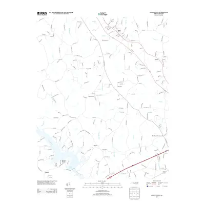
2013 Map of Stony Point
USGS Topo · Published 2013About this map
Stony Point and its neighboring communities of Sharon and Scotts sit within a landscape defined by the drainage of the Catawba River and the expanding waters of Lake Lookout. This modern survey illustrates the transition from the upland creek systems of Elk Shoals Cr and Third Cr toward the riverfront developments at Sunrise Beach and the curious settlement of Catfish. The local infrastructure is deeply tied to the land's hydrology, with roads like Island Ford hinting at earlier crossing points before modern bridges spanned the various branches. Notable for local researchers is the placement of Bradford Crossroads and the Flying BJ Airport, showing how aviation and small-town junctions continue to serve this rural Iredell County corridor. The network of family-named roads, such as Rogers Farm Ln and Lentz Rd, reflects a pattern of long-standing land ownership that persists alongside newer suburban growth.
Find a feature on this map
212 named features on this map. Tap any name to fly to it.
Don’t see what you’re looking for? This feature index may not catch every label — zoom into the map to look around manually.
Map Details
Editions of this 2013 Stony Point Map
This is the sole edition of this map. No revisions or reprints were ever made.
Other maps of this area

1893 · Statesville
USGS Topo · 1:125,000

1895 · Hickory
USGS Topo · 1:125,000

1953 · Charlotte
USGS Topo · 1:250,000

1954 · Charlotte
USGS Topo · 1:250,000

1960 · Charlotte
USGS Topo · 1:250,000

1962 · Charlotte
USGS Topo · 1:250,000

1969 · Troutman
USGS Topo · 1:24,000

1969 · Statesville West
USGS Topo · 1:24,000
1969 · Central
USGS Topo · 1:24,000
1970 · Hiddenite
USGS Topo · 1:24,000