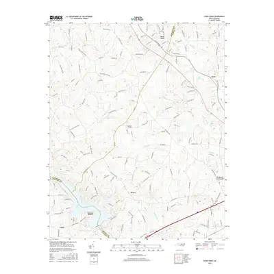
2016 Map of Stony Point
USGS Topo · Published 2016About this map
Stony Point serves as the primary community in this Piedmont landscape, situated where the borders of Alexander, Iredell, and Catawba counties converge. The terrain is defined by a dense network of waterways including Buffalo Shoals Cr, Third Cr, and Elk Shoals Cr, which drain southward toward the significant expanse of Lake Lookout. This reservoir shoreline is home to the developed area of Sunrise Beach, reflecting the region's mid-century shift toward lakefront recreation. Away from the water, the landscape remains characterized by small rural nodes such as Bradford Crossroads, Sharon, and Scotts. Genealogists may find interest in Beulah Cem and family-named landmarks like Rogers Farm Ln and Smith Farm Rd. The presence of the Flying BJ Airport and a grid of well-established rural routes illustrates the evolution of transportation and land use in this part of North Carolina.
Find a feature on this map
140 named features on this map. Tap any name to fly to it.
Don’t see what you’re looking for? This feature index may not catch every label — zoom into the map to look around manually.
Map Details
Editions of this 2016 Stony Point Map
This is the sole edition of this map. No revisions or reprints were ever made.
Other maps of this area

1893 · Statesville
USGS Topo · 1:125,000

1895 · Hickory
USGS Topo · 1:125,000

1953 · Charlotte
USGS Topo · 1:250,000

1954 · Charlotte
USGS Topo · 1:250,000

1960 · Charlotte
USGS Topo · 1:250,000

1962 · Charlotte
USGS Topo · 1:250,000

1969 · Troutman
USGS Topo · 1:24,000

1969 · Statesville West
USGS Topo · 1:24,000
1969 · Central
USGS Topo · 1:24,000
1970 · Hiddenite
USGS Topo · 1:24,000