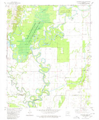
1980 Map of Strangers Home
USGS Topo · Published 1980About this map
The winding Black River dominates this 1980 survey, where the convergence of Lawrence, Independence, and Jackson counties meets the dense wetlands of the Shirey Bay - Rainey Brake State Wildlife Management Area. This landscape is defined by its complex hydrology, featuring numerous oxbows and backwaters like Horseshoe Lake, Brushy Lake, and Adams Brake. The interaction between the natural river course and man-made alterations is evident in the presence of a Floodgate and the transition from the Strawberry River into the Caney Cr Ditch.
Find a feature on this map
38 named features on this map. Tap any name to fly to it.
Don’t see what you’re looking for? This feature index may not catch every label — zoom into the map to look around manually.
Map Details
Editions of this 1980 Strangers Home Map
This is the sole edition of this map. No revisions or reprints were ever made.
Other maps of this area

1932 · Strawberry
USGS Topo · 1:62,500

1934 · Powhatan
USGS Topo · 1:62,500

1935 · Powhatan
USGS Topo · 1:62,500

1935 · Alicia
USGS Topo · 1:62,500

1935 · Strawberry
USGS Topo · 1:62,500

1941 · Strawberry
USGS Topo · 1:62,500

1953 · Memphis
USGS Topo · 1:250,000

1955 · Strawberry
USGS Topo · 1:24,000

1955 · Cord
USGS Topo · 1:24,000

1956 · Memphis
USGS Topo · 1:250,000