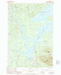
1989 Map of Stratton
USGS Topo · Published 1989About this map
The massive waters of Flagstaff Lake dominate this high-country landscape, where the North Branch Dead River and South Branch Dead River converge. The village of Stratton serves as the primary hub at the southern end of the lake, while the smaller settlement of Eustis sits tucked beneath the rising elevation of Eustis Ridge. The map reveals a land defined by water and wood, with numerous brooks such as Whiskey Brook and Lutton Brook draining the surrounding peaks.
Find a feature on this map
33 named features on this map. Tap any name to fly to it.
Don’t see what you’re looking for? This feature index may not catch every label — zoom into the map to look around manually.
Map Details
Editions of this 1989 Stratton Map
This is the sole edition of this map. No revisions or reprints were ever made.
Other maps of this area

1928 · Chain Lakes
USGS Topo · 1:48,000

1928 · Spencer
USGS Topo · 1:48,000

1928 · Stratton
USGS Topo · 1:48,000

1932 · Stratton
USGS Topo · 1:62,500

1932 · Kennebago Lake
USGS Topo · 1:48,000

1932 · Spencer
USGS Topo · 1:62,500

1932 · Chain Lakes
USGS Topo · 1:62,500

1935 · Kennebago Lake
USGS Topo · 1:62,500

1935 · Chain Lakes
USGS Topo · 1:62,500

1936 · Kennebago Lake
USGS Topo · 1:62,500