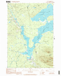
1997 Map of Stratton
USGS Topo · Published 2000About this map
Stratton and Eustis serve as the primary human anchors in this late-20th-century topographic record of the Western Maine Mountains. The landscape is dominated by the extensive waters of Flagstaff Lake and the Dead Flagstaff Lake, which fill the central valley where the North Branch and South Branch of the Dead River once met more distinctly. To the south, the massive presence of Bigelow Mountain rises sharply, with Cranberry Peak and East Nubble marking the high ridgelines that define the Bigelow township area.
Find a feature on this map
39 named features on this map. Tap any name to fly to it.
Don’t see what you’re looking for? This feature index may not catch every label — zoom into the map to look around manually.
Map Details
Editions of this 1997 Stratton Map
This is the sole edition of this map. No revisions or reprints were ever made.
Other maps of this area

1928 · Chain Lakes
USGS Topo · 1:48,000

1928 · Spencer
USGS Topo · 1:48,000

1928 · Stratton
USGS Topo · 1:48,000

1932 · Stratton
USGS Topo · 1:62,500

1932 · Kennebago Lake
USGS Topo · 1:48,000

1932 · Spencer
USGS Topo · 1:62,500

1932 · Chain Lakes
USGS Topo · 1:62,500

1935 · Kennebago Lake
USGS Topo · 1:62,500

1935 · Chain Lakes
USGS Topo · 1:62,500

1936 · Kennebago Lake
USGS Topo · 1:62,500