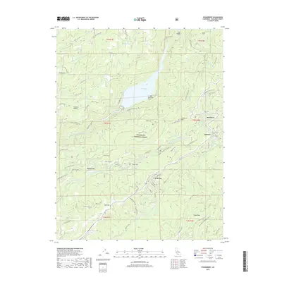
2018 Map of Strawberry
USGS Topo · Published 2018About this map
Stanislaus National Forest serves as the backdrop for this high-country landscape, where the waters of the Middle Fork Stanislaus River and South Fork Stanislaus River carve through the mountains. Central to the area is Beardsley Lake, a significant reservoir managed via the Philadelphia Ditch system. The map documents the recreational and residential infrastructure of the late 2010s, centered around the mountain settlements of Strawberry, Pinecrest, and Cold Springs. High-altitude terrain features such as Strawberry Peak and Bald Mtn overlook a network of forest routes and unique historical traces like the Straw / Fraser Flat RR Bike Tr. Toward the southern edge, the Dodge Ridge area highlights the region's long-standing role as a winter sports and outdoor destination. The map provides a detailed record of water management and forest access routes that define this portion of Tuolumne County.
Find a feature on this map
84 named features on this map. Tap any name to fly to it.
Don’t see what you’re looking for? This feature index may not catch every label — zoom into the map to look around manually.
Map Details
Editions of this 2018 Strawberry Map
This is the sole edition of this map. No revisions or reprints were ever made.
Other maps of this area

1891 · Big Trees
USGS Topo · 1:125,000

1894 · Big Trees
USGS Topo · 1:125,000

1896 · Dardanelles
USGS Topo · 1:125,000

1897 · Big Trees
USGS Topo · 1:125,000

1898 · Dardanelles
USGS Topo · 1:125,000

1901 · Big Trees
USGS Topo · 1:125,000

1947 · Sacramento
USGS Topo · 1:250,000

1948 · Walker Lake
USGS Topo · 1:250,000

1948 · Sacramento
USGS Topo · 1:250,000

1956 · Sacramento
USGS Topo · 1:250,000