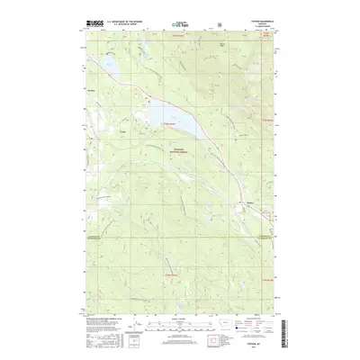
2017 Map of Stryker
USGS Topo · Published 2017About this map
Stryker and Trego serve as the primary coordinates for this 2017 survey of the Montana high country, where the Stillwater River cuts through the eastern edge of the Kootenai National Forest. The landscape is defined by its dramatic relief, most notably at Patrick Ridge and the cluster of alpine water bodies including Dickey Lake, Murphy Lake, and Haystack Lake. A complex network of timber and access roads, such as Natl Forest Develop Road 857 Rd and the Brimstone-Sunday Creek Rd, illustrates the modern management of this timber-rich region. The map captures the quiet intersection of these small mountain settlements with the broader wilderness of the Lincoln and Flathead county lines, providing a detailed record of drainage patterns from Cripple Cr to Brimstone Cr.
Find a feature on this map
43 named features on this map. Tap any name to fly to it.
Don’t see what you’re looking for? This feature index may not catch every label — zoom into the map to look around manually.
Map Details
Editions of this 2017 Stryker Map
This is the sole edition of this map. No revisions or reprints were ever made.
Other maps of this area

1913 · Stryker
USGS Topo · 1:125,000

1916 · Stryker
USGS Topo · 1:125,000

1957 · Kalispell
USGS Topo · 1:250,000

1960 · Kalispell
USGS Topo · 1:250,000

1961 · Kalispell
USGS Topo · 1:250,000

1963 · Mount Marston
USGS Topo · 1:24,000

1963 · Stryker
USGS Topo · 1:24,000
1963 · Skillet Mountain
USGS Topo · 1:24,000

1963 · Sunday Mountain
USGS Topo · 1:24,000
1963 · Edna Mountain
USGS Topo · 1:24,000