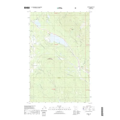
2020 Map of Stryker
USGS Topo · Published 2020About this map
The Whitefish Range and the high Patrick Ridge define the eastern terrain of this 2020 map, where the Kootenai National Forest blankets the landscape north of the Lincoln and Flathead County line. The settlement of Stryker sits at a lower elevation along the Stillwater River, serving as a focal point for local travel via Bull Lake Rd and Stryker-Upper Whitefish Rd.
Find a feature on this map
46 named features on this map. Tap any name to fly to it.
Don’t see what you’re looking for? This feature index may not catch every label — zoom into the map to look around manually.
Map Details
Editions of this 2020 Stryker Map
This is the sole edition of this map. No revisions or reprints were ever made.
Other maps of this area

1913 · Stryker
USGS Topo · 1:125,000

1916 · Stryker
USGS Topo · 1:125,000

1957 · Kalispell
USGS Topo · 1:250,000

1960 · Kalispell
USGS Topo · 1:250,000

1961 · Kalispell
USGS Topo · 1:250,000

1963 · Mount Marston
USGS Topo · 1:24,000

1963 · Stryker
USGS Topo · 1:24,000
1963 · Skillet Mountain
USGS Topo · 1:24,000

1963 · Sunday Mountain
USGS Topo · 1:24,000
1963 · Edna Mountain
USGS Topo · 1:24,000