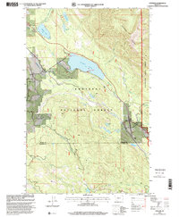
1997 Map of Stryker
USGS Topo · Published 2000About this map
Stillwater State Forest and the Kootenai National Forest dominate this landscape in Northwest Montana, where the terrain is defined by the steep incline of Patrick Ridge. The corridor following the Burlington Northern railroad serves as the primary artery for the region, connecting the small settlements of Trego and Stryker. This rail-dependent settlement pattern reflects the area's ongoing importance to the timber and transport sectors, even as recreational sites like Dickey Lake, Murphy Lake, and Jumbo Lake indicate a dual-use landscape of industry and tourism. A network of drainages including Laughing Water Creek, Brimstone Creek, and Summit Creek feeds into the Stillwater River, while localized industrial features like the Gravel Pit near Ant Flat show the active extraction required for local infrastructure maintenance.
Find a feature on this map
36 named features on this map. Tap any name to fly to it.
Don’t see what you’re looking for? This feature index may not catch every label — zoom into the map to look around manually.
Map Details
Editions of this 1997 Stryker Map
This is the sole edition of this map. No revisions or reprints were ever made.
Other maps of this area

1913 · Stryker
USGS Topo · 1:125,000

1916 · Stryker
USGS Topo · 1:125,000

1957 · Kalispell
USGS Topo · 1:250,000

1960 · Kalispell
USGS Topo · 1:250,000

1961 · Kalispell
USGS Topo · 1:250,000

1963 · Mount Marston
USGS Topo · 1:24,000

1963 · Stryker
USGS Topo · 1:24,000
1963 · Skillet Mountain
USGS Topo · 1:24,000

1963 · Sunday Mountain
USGS Topo · 1:24,000
1963 · Edna Mountain
USGS Topo · 1:24,000