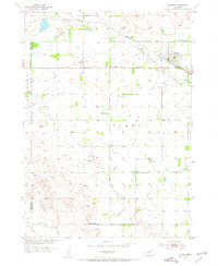
1954 Map of Stuart
USGS Topo · Published 1955About this map
Stuart serves as the primary hub of activity on this mid-century survey, situated along the Chicago and North Western railroad line. The landscape is defined by the drainage systems of the Elkhorn River, which is fed by the North Fork and South Fork in the northern reaches of the quadrangle. This map was produced as part of the Department of the Interior program for the development of the Missouri River Basin, reflecting the federal interest in water management and land use during the 1950s.
Find a feature on this map
12 named features on this map. Tap any name to fly to it.
Don’t see what you’re looking for? This feature index may not catch every label — zoom into the map to look around manually.
Map Details
Editions of this 1954 Stuart Map
2 editions found
Other maps of this area

1954 · Stuart
USGS Topo · 1:24,000

1954 · Stuart SE
USGS Topo · 1:24,000

1954 · Stuart NW
USGS Topo · 1:24,000

1954 · Newport NE
USGS Topo · 1:24,000

1954 · Newport
USGS Topo · 1:24,000

1954 · Stuart NE
USGS Topo · 1:24,000

1955 · O'Neill
USGS Topo · 1:250,000

1959 · O'Neill
USGS Topo · 1:250,000

1969 · O'Neill
USGS Topo · 1:250,000

1982 · Dora Lake
USGS Topo · 1:24,000