
1974 Map of Studley
USGS Topo · Published 1977About this map
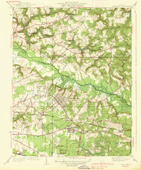
Pamunkey River winding through the rural landscape of Hanover County defines the northern reaches of this mid-1970s orthophotoquad. Unlike traditional topographic maps, this aerial perspective reveals the precise patterns of agriculture and forest cover across the Virginia coastal plain. The intricate patchwork of fields and woodlots reflects the agricultural character of the region just before significant suburban expansion began to alter the historical rural layout. Researchers and landowners can identify field boundaries, farm lanes, and the dense riparian vegetation lining the river's path, providing a high-fidelity visual baseline for the environment as it existed during this period.
Find a feature on this map
1 named feature on this map. Tap any name to fly to it.
Don’t see what you’re looking for? This feature index may not catch every label — zoom into the map to look around manually.
Map Details
Editions of this 1974 Studley Map
This is the sole edition of this map. No revisions or reprints were ever made.
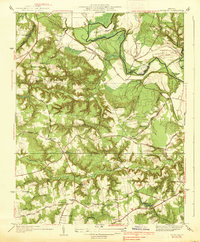
Other maps of this area

1894 · Richmond
USGS Topo · 1:62,500

1895 · Richmond
USGS Topo · 1:62,500

1918 · Doswell
USGS Topo · 1:62,500

1918 · Aylett
USGS Topo · 1:62,500

1920 · King William
USGS Topo · 1:62,500

1933 · Aylett
USGS Topo · 1:62,500

1934 · Seven Pines
USGS Topo · 1:24,000

1934 · Richmond
USGS Topo · 1:24,000
1938 · Seven Pines
USGS Topo · 1:31,680
1938 · Studley
USGS Topo · 1:31,680