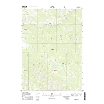
2017 Map of Stump Peak
USGS Topo · Published 2017About this map
Caribou National Forest dominates this high-altitude landscape in the southeastern corner of Idaho. The terrain is defined by the convergence of the Caribou Range and the Webster Range, creating a complex network of ridges and canyons. Water from these heights drains through numerous named watercourses, such as Tincup Cr and Stump Cr, which follow the natural folds of the mountains. The prominence of Stump Peak serves as a central landmark for the area, while the curiously named Suicide Pass provides a navigable crossing point through the high ridges. Human footprint on the land is minimal, represented primarily by Flat Valley Rd and forest service routes that trace the base of the peaks. For those studying the geography of this remote territory, the map reveals distinct landforms like Browns Canyon and Marshall Canyon, illustrating the erosional patterns that have shaped the Idaho-Wyoming borderlands.
Find a feature on this map
33 named features on this map. Tap any name to fly to it.
Don’t see what you’re looking for? This feature index may not catch every label — zoom into the map to look around manually.
Map Details
Editions of this 2017 Stump Peak Map
This is the sole edition of this map. No revisions or reprints were ever made.
Other maps of this area
1915 · Freedom
USGS Topo · 1:62,500
1915 · Lanes Creek
USGS Topo · 1:62,500
1932 · Irwin
USGS Topo · 1:96,000
1935 · Irwin
USGS Topo · 1:125,000
1951 · Upper Valley
USGS Topo · 1:24,000

1955 · Driggs
USGS Topo · 1:250,000

1955 · Preston
USGS Topo · 1:250,000
1958 · Driggs
USGS Topo · 1:250,000

1958 · Preston
USGS Topo · 1:250,000
1962 · Driggs
USGS Topo · 1:250,000