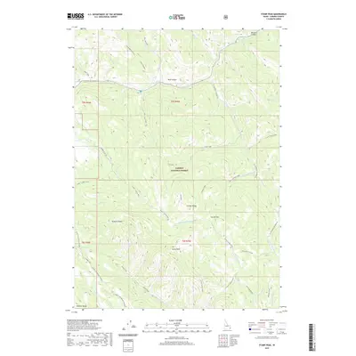
2020 Map of Stump Peak
USGS Topo · Published 2020About this map
Stump Peak and the high elevations of the Caribou Range dominate this part of eastern Idaho, where steep drainages flow toward the Salt River valley. This landscape is historically defined by the passage of the Lander Trail, a primary emigrant route that traversed this difficult terrain through Browns Canyon and along the Webster Range. The map reveals the intricate watershed network of the Caribou National Forest, including the headwaters of Stump Creek and the southern reaches of Tincup Cr. Modern management of this wilderness is reflected in routes like Caribou NF RD 139, though older paths like Lanes - Suicide Pass and the evocatively named Suicide Pass highlight the area's reputation for challenging travel. From the deep cuts of Bear Canyon to the alpine stretches of Tincup Mountain, the topography serves as a detailed record of the western migration corridor.
Find a feature on this map
50 named features on this map. Tap any name to fly to it.
Don’t see what you’re looking for? This feature index may not catch every label — zoom into the map to look around manually.
Map Details
Editions of this 2020 Stump Peak Map
This is the sole edition of this map. No revisions or reprints were ever made.
Other maps of this area

1915 · Freedom
USGS Topo · 1:62,500

1915 · Lanes Creek
USGS Topo · 1:62,500

1932 · Irwin
USGS Topo · 1:96,000

1935 · Irwin
USGS Topo · 1:125,000
1951 · Upper Valley
USGS Topo · 1:24,000

1955 · Driggs
USGS Topo · 1:250,000

1955 · Preston
USGS Topo · 1:250,000

1958 · Driggs
USGS Topo · 1:250,000

1958 · Preston
USGS Topo · 1:250,000

1962 · Driggs
USGS Topo · 1:250,000