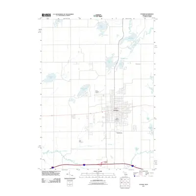
2011 Map of Sturgis
USGS Topo · Published 2011About this map
Sturgis serves as the primary hub of this 2011 survey, situated at the intersection of significant regional transport routes just north of the Indiana state line. The city's grid is anchored by the Sturgis Post Office and Oak Lawn Cemetery, while the Kirsch Municipal Airport provides aviation infrastructure to the northwest. This landscape is defined by its glacial hydrology, featuring a dense network of lakes such as Minnewaukan Lake, Omena Lake, and Eight Foot Lake. To the north, the Prairie River meanders through the terrain, while the Fawn River and Nye Drain define the southern drainage patterns. For genealogists and local historians, the map preserves the locations of several burial grounds, including the Tobey Cemetery and Sturgis Memorial Gardens Cemetery. The southern edge also features the Howe-Lagrange Tollgate and Green Valley Campground, reflecting the area's role in interstate travel and recreation.
Find a feature on this map
28 named features on this map. Tap any name to fly to it.
Don’t see what you’re looking for? This feature index may not catch every label — zoom into the map to look around manually.
Map Details
Editions of this 2011 Sturgis Map
This is the sole edition of this map. No revisions or reprints were ever made.
Other maps of this area

1914 · Three Rivers
USGS Topo · 1:62,500

1916 · Three Rivers
USGS Topo · 1:62,500

1943 · Three Rivers
USGS Topo · 1:62,500

1947 · Mongo
USGS Topo · 1:24,000

1947 · Lagrange
USGS Topo · 1:24,000

1953 · Fort Wayne
USGS Topo · 1:250,000

1956 · Fort Wayne
USGS Topo · 1:250,000
1960 · Lagrange
USGS Topo · 1:24,000
1960 · Mongo
USGS Topo · 1:24,000
1961 · Sturgis
USGS Topo · 1:24,000