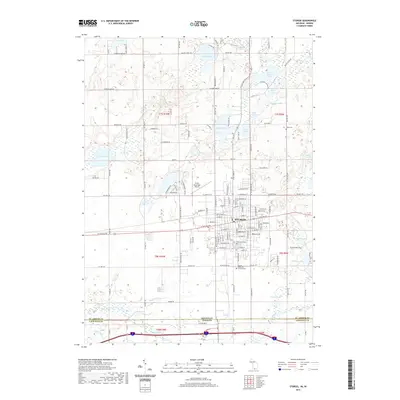
2019 Map of Sturgis
USGS Topo · Published 2019About this map
Sturgis anchors this 2019 survey, sitting at the junction of several regional transit corridors along the Michigan-Indiana border. The urban grid is clearly defined, supporting local infrastructure such as the Kirsch Municipal Airport and several historic burial sites, including Oak Lawn Cem and Sturgis Memorial Gardens Cem. The landscape to the north and east is defined by a dense concentration of glacial kettle lakes, including Perrin Lake, Prairie River Lake, and Fish Lake.
Find a feature on this map
137 named features on this map. Tap any name to fly to it.
Don’t see what you’re looking for? This feature index may not catch every label — zoom into the map to look around manually.
Map Details
Editions of this 2019 Sturgis Map
This is the sole edition of this map. No revisions or reprints were ever made.
Other maps of this area

1914 · Three Rivers
USGS Topo · 1:62,500

1916 · Three Rivers
USGS Topo · 1:62,500

1943 · Three Rivers
USGS Topo · 1:62,500

1947 · Mongo
USGS Topo · 1:24,000

1947 · Lagrange
USGS Topo · 1:24,000

1953 · Fort Wayne
USGS Topo · 1:250,000

1956 · Fort Wayne
USGS Topo · 1:250,000
1960 · Lagrange
USGS Topo · 1:24,000
1960 · Mongo
USGS Topo · 1:24,000
1961 · Sturgis
USGS Topo · 1:24,000