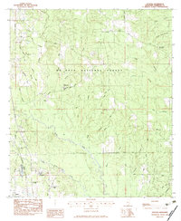
1982 Map of Success
USGS Topo · Published 1983About this map
The De Soto National Forest dominates this Harrison County landscape, where the Little Biloxi River carves a winding path through the southern timberlands. The settlement of Success sits at the intersection of Ira Johnson Road and School Road, serving as a focal point for a rural community defined by its scattered family cemeteries and small churches. In the southwest, the community of Lyman marks a more developed corridor, anchored by the Harrison Central High School and the Fish Hatchery near the Illinois Central Gulf railroad line.
Find a feature on this map
57 named features on this map. Tap any name to fly to it.
Don’t see what you’re looking for? This feature index may not catch every label — zoom into the map to look around manually.
Map Details
Editions of this 1982 Success Map
This is the sole edition of this map. No revisions or reprints were ever made.
Other maps of this area

1953 · Mobile
USGS Topo · 1:250,000

1954 · Vestry
USGS Topo · 1:62,500

1954 · McHenry
USGS Topo · 1:62,500

1954 · Gulfport North
USGS Topo · 1:24,000

1954 · Biloxi
USGS Topo · 1:24,000

1954 · Biloxi
USGS Topo · 1:62,500

1956 · Gulfport NW
USGS Topo · 1:24,000

1957 · Mobile
USGS Topo · 1:250,000

1960 · Mobile
USGS Topo · 1:250,000

1963 · Mobile
USGS Topo · 1:250,000