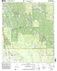
2000 Map of Success
USGS Topo · Published 2002About this map
The Harrison Experimental Forest and De Soto National Forest dominate this Harrison County landscape, where timber management and research lands meet the north-flowing tributaries of the coast. The settlement of Success sits at a crossroads in the northern portion of the sheet, while the southern edge captures the burgeoning development around Lyman. The hydrology of the region is defined by the Biloxi River and Little Biloxi River, which carve through the pine-laden terrain. This map reveals a specific mix of rural institutional life and industrial infrastructure, ranging from the Gaging Station and Harrison Lookout tower to the Sewage Lagoon and Gravel Pit. Genealogists will find several family-named burial grounds and local landmarks, including the Blackwell Cem and Morris Hill Ch, Williams Cem, and Saucier Cem, which document the long-standing community footprint in this forested corridor.
Find a feature on this map
54 named features on this map. Tap any name to fly to it.
Don’t see what you’re looking for? This feature index may not catch every label — zoom into the map to look around manually.
Map Details
Editions of this 2000 Success Map
This is the sole edition of this map. No revisions or reprints were ever made.
Other maps of this area

1953 · Mobile
USGS Topo · 1:250,000

1954 · Vestry
USGS Topo · 1:62,500

1954 · McHenry
USGS Topo · 1:62,500

1954 · Gulfport North
USGS Topo · 1:24,000

1954 · Biloxi
USGS Topo · 1:24,000

1954 · Biloxi
USGS Topo · 1:62,500

1956 · Gulfport NW
USGS Topo · 1:24,000

1957 · Mobile
USGS Topo · 1:250,000

1960 · Mobile
USGS Topo · 1:250,000

1963 · Mobile
USGS Topo · 1:250,000