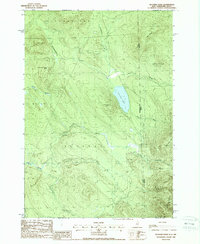
1988 Map of Success Pond
USGS Topo · Published 1988About this map
Success Pond sits at the center of this high-elevation landscape along the border of New Hampshire and Maine. Located primarily within the township of Success, the area is defined by sharp ridgelines and the headwaters of numerous mountain streams. The terrain rises significantly toward the Mahoosuc Range in the southeast, where peaks like Goose Eye Mtn and Mahoosuc Mtn dominate the horizon. In the late 1980s, this area was managed largely for timber and recreation, evidenced by the network of private roads and the presence of a Boat Ramp and Shelter near the pond's edge. Industrial activity is indicated by several Gravel Pits located near Blackstrap Brook. The map captures the meeting of Coos and Oxford counties, illustrating a remote section of the northern woods where logging infrastructure and natural landmarks like Chickwolnepy Mtn converge.
Find a feature on this map
31 named features on this map. Tap any name to fly to it.
Don’t see what you’re looking for? This feature index may not catch every label — zoom into the map to look around manually.
Map Details
Editions of this 1988 Success Pond Map
This is the sole edition of this map. No revisions or reprints were ever made.
Other maps of this area

1893 · Gorham
USGS Topo · 1:62,500

1896 · Gorham
USGS Topo · 1:62,500

1914 · Bethel
USGS Topo · 1:62,500

1930 · Milan
USGS Topo · 1:62,500

1933 · Milan
USGS Topo · 1:62,500

1934 · Milan
USGS Topo · 1:62,500

1937 · Gorham
USGS Topo · 1:48,000

1940 · Bethel
USGS Topo · 1:62,500

1941 · Bethel
USGS Topo · 1:62,500

1942 · Gorham
USGS Topo · 1:62,500