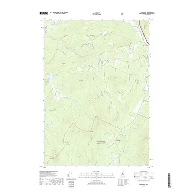
2018 Map of Sugar Hill
USGS Topo · Published 2018About this map
Sugar Hill and the surrounding villages of Franconia and Easton define this landscape within the White Mountain National Forest. The map documents a topography of prominent elevations such as Bronson Hill and Garnet Hill, separated by a dense network of mountain brooks including Bowen Brook and Scotland Brook. Local history is anchored by several burial grounds, notably Sunny-Side Cem near the center of the quadrangle and Kinsman Cem further south. The Ammonoosuc River and Gale River frame the northern reaches of the area, while the southern portion transitions into the wilderness of the national forest near Jericho and Cobble Hill. Civil infrastructure like the Franconia Airport and a complex web of named rural roads, such as Breezy Hill Rd and Jim Noyes Hill Rd, indicate the long-standing settlement patterns of this New Hampshire mountain region.
Find a feature on this map
91 named features on this map. Tap any name to fly to it.
Don’t see what you’re looking for? This feature index may not catch every label — zoom into the map to look around manually.
Map Details
Editions of this 2018 Sugar Hill Map
This is the sole edition of this map. No revisions or reprints were ever made.
Other maps of this area

1900 · Whitefield
USGS Topo · 1:62,500

1929 · Moosilauke
USGS Topo · 1:62,500

1929 · Franconia
USGS Topo · 1:62,500

1931 · Littleton
USGS Topo · 1:62,500

1932 · Franconia
USGS Topo · 1:62,500

1932 · Littleton
USGS Topo · 1:48,000

1932 · Moosilauke
USGS Topo · 1:62,500

1935 · Littleton
USGS Topo · 1:62,500

1935 · Whitefield
USGS Topo · 1:48,000

1938 · Whitefield
USGS Topo · 1:62,500