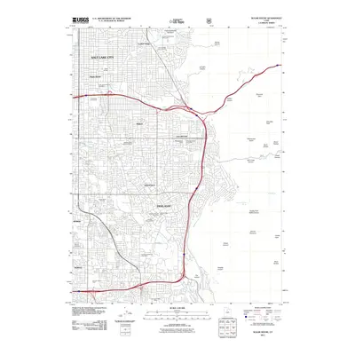
2011 Map of Sugar House
USGS Topo · Published 2011About this map
Sugar House serves as a prominent commercial and residential hub within the southeastern reaches of Salt Lake City, characterized by a dense grid that transitions abruptly into the steep canyons of the Wasatch Range. The 2011 landscape is defined by its social infrastructure, featuring numerous cemeteries such as Wasatch Lawn Memorial Park and Elysian Burial Gardens, alongside local landmarks like Hogle Zoological Gardens and the Wheeler Historic Farm. The transition from urban centers like Holladay and Murray to the wilderness of Parleys Canyon and Mount Olympus is marked by Wasatch Blvd, which skirts the base of peaks including Grandeur Peak and Hobbs Peak. Waterways like Emigration Creek and Parleys Creek flow from these highlands into the valley, while the presence of specific postal facilities like the Sugar House Station Post Office and Cottonwood Post Office provides essential points of reference for local genealogy and neighborhood history.
Find a feature on this map
54 named features on this map. Tap any name to fly to it.
Don’t see what you’re looking for? This feature index may not catch every label — zoom into the map to look around manually.
Map Details
Editions of this 2011 Sugar House Map
This is the sole edition of this map. No revisions or reprints were ever made.
Other maps of this area

1885 · Salt Lake
USGS Topo · 1:250,000

1925 · Ft. Douglas
USGS Topo · 1:125,000

1928 · Ft. Douglas
USGS Topo · 1:125,000

1950 · Fort Douglas
USGS Topo · 1:24,000

1951 · Fort Douglas
USGS Topo · 1:24,000

1951 · Salt Lake City South
USGS Topo · 1:24,000

1951 · Midvale
USGS Topo · 1:24,000

1951 · Salt Lake City North
USGS Topo · 1:24,000

1952 · Sugar House
USGS Topo · 1:24,000
1952 · Draper
USGS Topo · 1:24,000