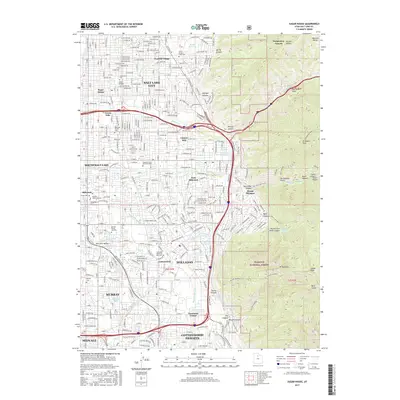
2017 Map of Sugar House
USGS Topo · Published 2017About this map
The eastern residential neighborhoods of Salt Lake City meet the foothills of the Wasatch Range in this modern topographic record. Central to the sheet is the historic Sugar House district, a hub of commerce and community that developed around early industrial sites. The landscape is characterized by a dense network of suburban expansion, stretching from Foothill Village in the north through the established communities of East Millcreek, Holladay, and Cottonwood. This residential fabric is interwoven with educational and commemorative spaces, including the campus of Westminster College and extensive grounds at Wasatch Lawn Memorial Park and Elysian Burial Gardens.
Find a feature on this map
81 named features on this map. Tap any name to fly to it.
Don’t see what you’re looking for? This feature index may not catch every label — zoom into the map to look around manually.
Map Details
Editions of this 2017 Sugar House Map
This is the sole edition of this map. No revisions or reprints were ever made.
Other maps of this area

1885 · Salt Lake
USGS Topo · 1:250,000

1925 · Ft. Douglas
USGS Topo · 1:125,000

1928 · Ft. Douglas
USGS Topo · 1:125,000

1950 · Fort Douglas
USGS Topo · 1:24,000

1951 · Fort Douglas
USGS Topo · 1:24,000

1951 · Salt Lake City South
USGS Topo · 1:24,000

1951 · Midvale
USGS Topo · 1:24,000

1951 · Salt Lake City North
USGS Topo · 1:24,000

1952 · Sugar House
USGS Topo · 1:24,000
1952 · Draper
USGS Topo · 1:24,000